Ordnance Survey has announced that over 70% of local authorities and 90% of highways authorities have signed up to share data on their critical underground assets on the National Underground Asset Register (NUAR), with authorities already reporting time and efficiency savings of 75%.
NUAR is a government digital service that provides secure, instant access to a map of underground pipes and cables. Operated by Ordnance Survey on behalf of the Government, it shares buried infrastructure data for telecoms, energy, water, transport, local authorities and highways authorities. So far, over 80% of known underground assets are mapped, with over 360 asset owners’ data published, covering more than 3.2 million km of pipes and cables.
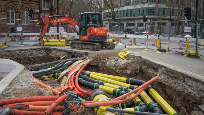
OS has been working hard supporting local and highways authorities to share data about the whereabouts of the assets they own and manage, including buried cables, traffic lights and signals, illuminated signs, parking meters, EV charging points, street lighting, district heating systems, gullies and culverts, and CCTV, into NUAR.

Rob West, Acting Assistant Engineer at Coventry City Council, added:
“Before NUAR, we would have to log into multiple providers, each with a different user interface, which was a very jarring and inefficient way of working compared to NUAR. We were also unknowingly chasing to find out who owned our own assets. If you like efficiency – and more information sign up to NUAR.”
As of March 2026, 62% of all local authorities in England, Wales and Northern Ireland have shared data for their underground infrastructure. This extends to 74% when organisations signed up to share their data are included.
Meanwhile, 81% of highways authorities in England and Wales have already shared data for their underground infrastructure, including Devon County Council, which, according to the UK Government, has the largest road network, and Kent County Council, which looks after the third largest road network. This figure extends to 91% when organisations signed up to share their data are included.
Local authority assets such as street lighting cables and feeds to illuminated traffic signs and traffic signals can often be just as risky to excavate as more obvious utility assets. If this infrastructure is damaged – for example, if traffic signals fail – the impact on the transport network can be significant. It can affect access to hospitals, schools and businesses, creating disruption for residents and harming local economies.
Accidental strikes on highways drainage infrastructure may not have an immediate impact, yet damage to drainage systems can have a devastating effect on local communities through flooding – sometimes several years later. With more highways authorities coming on board to feed highways drainage asset data into NUAR, it is much clearer for excavators to be aware of these assets during the pre‑dig planning phase, before they start breaking ground.
Other useful information being shared by the wider local authority community includes Conservation Areas and Tree Preservation Orders, assisting the protection of national heritage and the environment, as well as preventing disruption and delays if damage is inadvertently caused to historic paving in towns and cities, or to the roots of protected trees.
Durham County Council’s Drainage and Coastal Protection Manager, Brian Weatherall, said:
“NUAR is a real game changer and speeds up the work so much – and speed is money. The quicker we can get onto a job and the quicker we can solve a problem, the cheaper it is.
“Previously, with older systems that I’ve been involved with for 20 to 30 years, it can take a couple of weeks to find out where services underground are. In an emergency, you wouldn’t be able to wait that long. You would have to go in and hand dig very carefully, with the associated hazards that come with that.
“The game changer with NUAR is that we know almost instantly exactly what we are dealing with in the ground. Often, it will lead to the solution as well. If there are a lot of services in that area, it is quite common for those to interfere with highways drainage, so NUAR can lead us to where we need to look.”
NUAR is significant for all local and highways authorities, contractors and asset owners operating in the underground ecosystem. Making multiple manual requests to obtain information about underground assets is cut from days to minutes.
It supports 24/7 operations and self‑service access, reducing dependency on, and waiting times for, retrieving data from the back office. If an accidental strike occurs, NUAR helps emergency response times with immediate access to verified utility data, speeding up safe isolation and restoration of power.
In locations where combined authorities and transport authorities operate different infrastructure, NUAR provides clarity by showing on a map who owns what infrastructure and where.
Lincolnshire County Council’s Traffic Manager, Ashley Behan, commented:
“NUAR provides a central place for all asset owners’ information. This allows processes to be streamlined and the timeframe for gathering information to be significantly expedited, giving time and efficiency savings of approximately 75% when the system is fully in use.”
Publish once and serve many
NUAR Account Manager Ian David explained that high volumes of street works enquiries and requests for asset locations and connections were a never‑ending headache for local authorities, as they were costly, resource‑heavy and caused duplication.
“For local authorities that haven’t signed up to NUAR yet, we encourage you to do so to ensure full coverage within the service, further improving the benefits to all users in time, cost and safety.”
For more information about NUAR visit www.nuar.uk
(Picture: Ordnance Survey)