A team of researchers from Massachusetts say a micro-navigation smartphone app to they have developed has a “substantially” higher success rate than Google Maps in helping blind or visually impaired people find bus stops.
The team at Mass Eye and Ear explain that current GPS systems have sufficient macro-navigation for planning routes using public transport, but that micro-navigation, such as finding the exact locations of bus stops and destinations, has remained an issue for people who are BVI, as GPS-based localisation for this is less accurate.
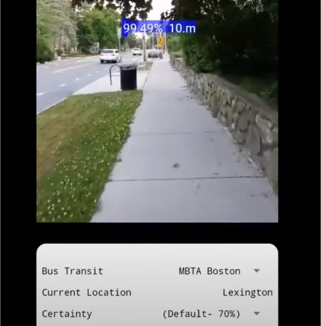
They have developed a mobile app called All_Aboard, which is meant to be used in conjunction with mainstream GPS systems and focuses on improving micro-navigation. When a GPS indicates that a BVI user is nearing their destination, that is when All_Aboard should be opened. The app uses the phones’ camera to detect street signs from 30 to 50 feet away. It then uses auditory cues to direct the user towards their destination, with the frequency of the sounds changing as they approach the end point.

The app uses AI and a deep learning neural network trained on about 10,000 images of bus stops collected in a given city or region. It is currently capable of recognising bus stops in 10 major cities/regions around the world.
In the study, 24 BVI individuals used All_Aboard along with Google Maps to navigate a set route with 10 bus stops at an urban (Boston) and suburban site (Newton, Mass.). The results of the study were measured in terms of localization error and rate of successful localisation. Localisation error, or gap distance, is defined as the distance between the desired destination and maps marked end point. The rate of successful localization is the probability of getting close enough to the bus stops. The researchers found that in both urban and suburban locations, All_Aboard had a success rate of 93%, whereas Google Maps had a 52% success rate. Additionally, the average gap distance with Google Maps was 6.62m and 1.54m with All_Aboard.
GPS accuracy is supposed to be acceptable in suburban areas, according to Luo, who added it was not initially expected that the performance with Google Maps in Newton, Mass. would be so low. Previous research from Luo and his team found this problem may be due to widespread errors in bus stop location mapping data in Google Maps.
“Our findings suggest that the All_Aboard app could help travelers with visual impairments in navigation by accurately detecting the bus stop, and therefore greatly reducing their chance of missing buses due to standing too far from the bus stops,” said Gang Luo, PhD, of the Schepens Eye Research Institute of Mass Eye and Ear. “This study indicates that computer vision-based object recognition capabilities can be used in a complementary way and provide added benefit to purely mapping-based, macro-navigation services in real-world settings.
(Picture – Mass Eye and Ear YouTube)