Flooding has been a long-standing and increasing problem for North Yorkshire County Council as well as residents and visitors to Wensleydale. A particular stretch of the A684 between Bainbridge and Wensley is often affected by flooding due to its location close to the River Ure and its flood plain. Andrew Walker and Jennifer Neve explain.
They will be giving more details during the JCT Traffic Signals Symposium at Nottingham Trent University on 15 and 16 September. This is an excerpt from what they will be talking about.
According to data recorded by the Environment Agency, there is a risk of flooding to low-lying land, including the affected stretch of road, once river levels hit 2.5m at the monitoring station on the Ure at Bainbridge. On the 4th of November 2020, the chart below shows that water levels reached 4.08 metres after rainfall that would usually be expected throughout November fell in a 24 hour period as the UK experienced the tail-end of Hurricane Zeta. Local fire and rescue services had to rescue 9 people from vehicles after a lorry and 5 cars became stranded in the flood waters on the A684 at Wensley.

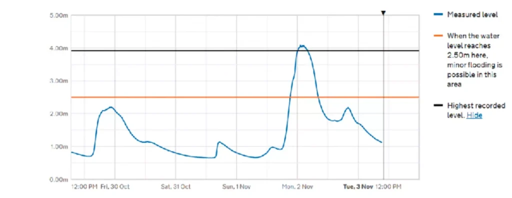
Image: Environment Agency
Location
Wensleydale sits at the heart of the Yorkshire Dales and is famed for its scenery and cheese. Wensleydale is home to the River Ure which flows from West to East, eventually meeting its neighbour, the River Swale, which becomes the Ouse and then heads toward the Humber Estuary via York.
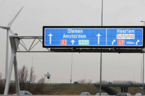
A flood warning system for drivers had previously been explored as an option by North Yorkshire County Council (NYCC) but the necessary funding wasn’t available at the time. Currently, when flooding occurs, NYCC rely on members of the public to inform them of the event. Response to a flooding event is therefore limited to office hours. Only once NYCC have been informed can they attend site and manually deploy signage to inform the road users of the situation using one of the existing plate signs pictured below.
In 2020, as part of its Safer Roads Fund initiative, North Yorkshire County Council finally had funding available to proceed. The aim of the scheme is to reduce incidents better informing road users of flooding and resulting road closures in a timely manner. The scheme addresses this through automating the system which will detect the flooding and inform road users and other stakeholders of the road closure through Variable Message Signs and an email notification system.
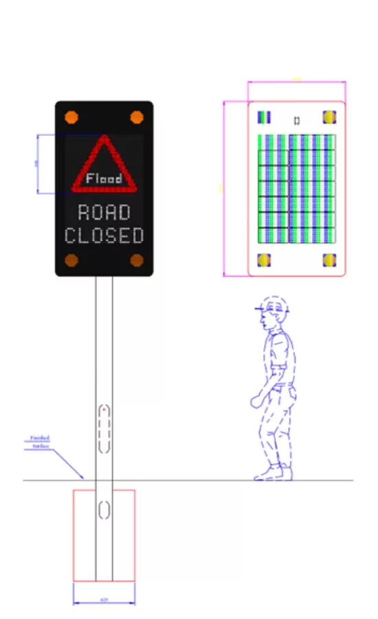
The initial scope outlined by NYCC included a requirement for 4 flood detection cabinets and 7 full colour RGB Variable Message Signs. To save power, reduce light pollution and avoid disturbance to residents, the VMS feature above ground vehicle detection that can be used to prevent sign activation unless a vehicle is detected approaching the sign location.
Locations
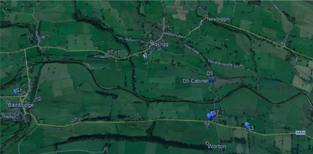
Bainbridge and Worton. Image (and others) from GoogleEarth
Flood warning signs are located at the points marked S1, S2, S3 and S7 on the Google Earth view above, with a flood detection cabinet at D5. D5 is on a potential diversion route and floods when a small, often dried up, beck is affected by heavy rainfall and run-off. Sign S1, approaching Bainbridge from the west (i.e. from Hawes) activates when flooding is detected further downstream and is located to enable the alternative route via Askrigg to be used, though this road is not suitable for large HGVs. Sign S2 and S3 also activate for eastbound traffic when flooding is detected further downstream
Floodplain at D5:
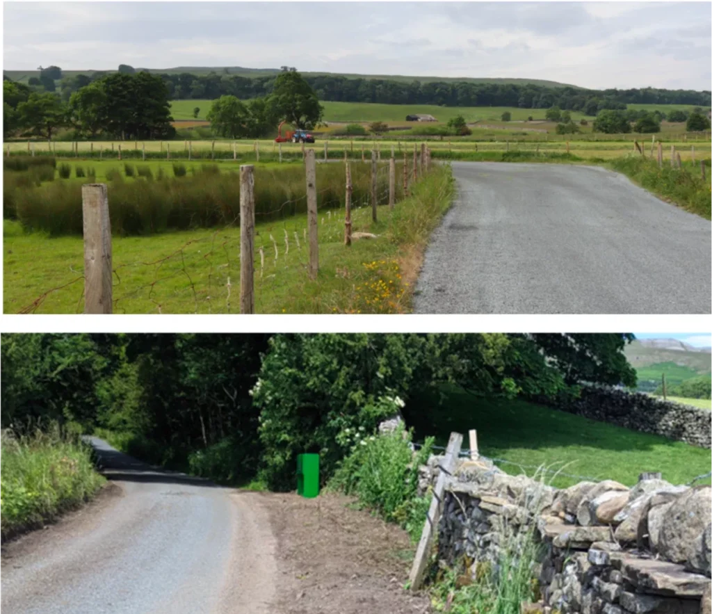
The cabinet and flood detection pit for D5 are shown above, with the cabinet sited to minimise its visual impact.
Technology Used
Signs a have a full matrix area to enable future setting of messages which are not flood related, providing further flexibility of the solution.
Image showing signs designed to fit within the space available on verges and minimising visual intrusion when not in use:
Detecting Flooding
Flooding is detected by Sick pressure sensors housed in subterranean chambers. These not only fill with water during flood events but become submerged under the standing water. The Sick pressure sensors have a transducer which converts water pressure into a 20mA analogue output. The typical car park outstation has been adapted to monitor this sensor and convert the water level into a car park count.
Using the UTMC car park count outstation interface this water level is transmitted to the central system. With no water pressure, the detection reports “Spaces”. The next threshold, nearly flooded, reports “Nearly Full”, and “Full” is reported when flooding is happening. The pressure thresholds are related to the head of water above the sensor at the same height as the road surface and can be adjusted using SWARCO’s hosted management software.
The sensors are connected to a control and communications cabinet which is located nearby and at height to avoid flood damage to the components. These are battery powered with fuel cells to keep the battery at the correct operating voltage. Each fuel cell is calculated to have sufficient fuel (ethanol) to operate for up to two years. Fuel will be topped up at each annual maintenance visit. Remote Monitoring will generate alarms should fuel run low between these visits.
Maintenance and support for the field equipment and the central management software will be provided by SWARCO for a period of 10 years, during which this ITS application is expected to save a lot of disruption and possibly lives.
At SWARCO, Andrew Walker is Business Development Manager and Jennifer Neve is Marketing Manager