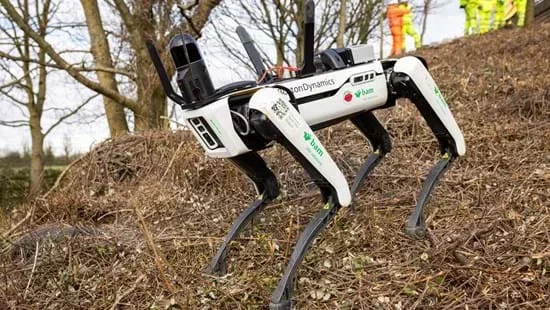
A robotic dog is being employed by National Highways as part of its survey work in the South West.
Spot, Boston Dynamics’ autonomous robot dog, is being trialled by National Highways, BAM Ritchies and AECOM as part of geotechnical surveys across a number of locations in the South West, and video footage of the first live trial can be seen on the company’s asset library.
To inform forthcoming operational work, the robotic dog’s eye view is being employed to capture data remotely in difficult-to-reach locations and across various terrains alongside the motorway and major A road network.

These access constrained sites include steep-sided embankments and natural slopes, slopes beneath tree canopies or otherwise obscured by vegetation, culverts, and under bridges and other structures.
National Highways says the use of this autonomous survey platform provides a safer and cost-effective option where inaccessible areas present difficulties and challenges to geotechnical inspectors.
Following standards set out in the Design Manual for Roads and Bridges and efforts to reduce the frequency of physical walkover surveys by inspectors and the need for costly and disruptive traffic management, National Highways, AECOM and BAM Ritchies, the ground engineering specialists of BAM UK and Ireland, are working together to bring this innovation into their working practices.
Spot has already been put through its paces by the AECOM and BAM teams at National Highways’ Development Centre at Moreton-in-Marsh last summer, where the robot’s capabilities were tested over a number of highways settings, across differing ground conditions and on earthworks of various gradients, heights and materials.
National Highways is expecting the remote technology to provide a higher level of detail and is undertaking live trials with the robotic device in the South West to explore and determine its capabilities.
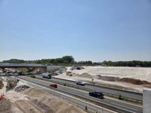
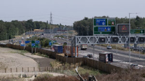
The four-legged robot has been employed in its first ‘live trial’ alongside the M5 in Somerset, using cameras and a Leica lidar tracker, and keen to explore and test the technology further, the company is examining more locations for other geotechnical surveys throughout the year.
Guy Swains, Engineering Manager within National Highways’ South West Geotechnical team, said: “The initial, ‘proof of concept’ testing has been encouraging and we’re now live trialling the robotic tool with a view to utilising it via our contractors in future survey work, particularly in locations which present challenges for our traditional methods.
“Our structures team are currently working on renewing certain elements of the St Georges railway bridge between junctions 20 and 21 of the M5, and identified a number of geotechnical defects in the ground surface.
“We were brought in to look into the detailed visual inspection and felt it provided an ideal opportunity to give Spot its first run.
“As part of an ongoing exploration, Spot’s capabilities will be tested over a variety of terrains and environments and in differing weather and ground conditions.
“The data from the trials will also be captured and analysed and dependent on results, hopefully we’ll be able to measure an improvement in safety methods and efficiencies and employ the technology in our future work.”
Matt Ewing, BAM Ritchies’ Business Development Manager, said: “Technology can keep our people safe and repeatedly capture high quality data, and having Spot undertake these trials demonstrates capability and evidence for further trials while making efficiencies in the delivery of work today.
“It’s about finding the right applications, and the team is focused on realising Spot’s potential.”
AECOM have been working alongside National Highways and the BAM Ritchies team to implement the trials and ensure they are robust, accurately reflecting the constraints of the highway corridor and aligning with operational needs and the geotechnical inspection requirements of the DMRB
James Codd, AECOM’s Associate Director of Ground Engineering, said: “It’s a significant step, and could complement the existing geotechnical asset management and inspection processes, to improve the safety of inspectors and reduce the impact of their activities on people’s journeys.
“We are working closely with the teams and really believe there could be a permanent place for Spot in the geotechnical asset management toolkit.”
The trials follow several National Highways’ research and development projects, led by the ARUP/AECOM consortium, which have been seeking to better integrate remote survey techniques into geotechnical asset management practice.
And the initiative comes within months of National Highways, the University of Cambridge and supply chain companies launching the Roads Research Alliance to shape the development of innovation within the highways industry over the next five years.