Traffic data and analytics company INRIX has launched a new AI-powered transportation monitoring solution for traffic control centres that its says offers extensive visibility into on-road conditions.
Leveraging INRIX’s data network of hundreds of millions of connected vehicles and devices, and its real-time roadway alerts, the company says INRIX IQ Mission Control is a “significant advancement in transportation management operations – providing accurate, cost-efficient, and reliable traffic insights in and across any size city”.
It explains INRIX Mission Control analyses and transforms data generated from connected vehicles and devices into “actionable insights for users to improve traffic flow, enhance road safety, improve incident response, and plan more effectively for future transportation needs”.
The cloud-based solution provides detailed visibility into traffic and roadway conditions on every major road type, while supplementing and reducing physical infrastructure, such as cameras or loop detectors. INRIX uses historical and real-time data, along with roadway alerts, to help predict travel demand and habits, in near real-time.
The company adds that INRIX Mission Control will integrate generative artificial intelligence “for even more profound benefits” explaining that INRIX Compass, INRIX’s new GenAI technology, adds an intuitive query interface that puts nearly 50 petabytes worth of rich transportation data at fingertips by “simply asking questions”. It adds that Compass will open the door for users to get answers to questions that were once beyond reach, thanks to the depth and breadth of data now available. Mission Control powered by Compass will accurately identify transportation issues, reveal causes, and offer unprecedented predictive insights.
“Agencies of all sizes can now leverage data-driven insights and AI to optimize traffic flow, enhance safety, and plan more effectively,” said Raine Bergstrom, chief product officer at INRIX, “Mission Control is crucial for agencies seeking intelligent transportation systems (ITS) capabilities at a fraction of the cost and complexity of traditional methods.”
Mission Control’s data-rich solution empowers transportation agencies with a level of visibility and insight into traffic conditions previously unattainable. Key features of Mission Control include:
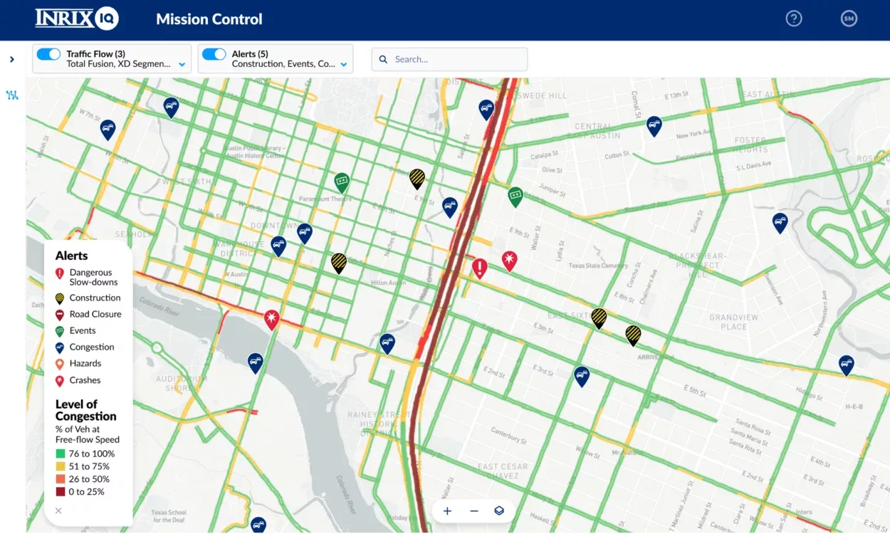
- Intuitive Interactive Visualizer: A user-friendly interface that presents traffic data in a map format, enabling easy navigation and interpretation of traffic conditions.
- Real-Time & Historical Traffic Flow: The tool visualizes current traffic congestion levels using a heatmap, providing an immediate understanding of traffic density and movement patterns.
- Customisable Filter Options: Traffic flow can by filtered by Level of Congestion, Speeds, or Relative to Free Flow Speed. Visualization can be further filtered by road type.
- Real-Time Roadway Alerts: Pinpoint issues with layers for various types of incidents such as Dangerous Slowdowns, Construction, Road Closure, Events, Congestion, and Hazards.
- Comprehensive Details: By clicking on specific road segments or alerts, users can access details such as Current Average Travel Time, Current Average Speed, Free Flow Speed, Historic Average Speed and Severity Level of congestion.
- Global Coverage: The traffic data covers over 5 million miles of roads in 47 countries providing detailed information across a wide range of road types and classes to provide a broad picture of traffic conditions.
(Screenshot – INRIX)


