As part of the Highways News Theme Week on Traffic Management, James Guilliatt of the City of York Council and Nancy Bunyan from Dynniq UK and Ireland give a background into the implementation of a Green Light Optimised Speed Advisory system in York.
More details about this project will be given at the JCT Traffic Signals Symposium in Nottingham, which takes place on 15 and 16 September. This article is an abridged version of the paper.
GLOSA is a mechanism to advise drivers of the optimal speed to pass through traffic signals smoothly, without stopping, offering the benefits of improved traffic flow, reduced idling time, fewer emissions and less driver stress. Why wouldn’t you want those benefits?

York is a vibrant city, with traffic congestion, emissions and accessibility challenges similar to many other cities in the UK.
Building on the success of previous research and delivery projects, City of York Council
(CoYC) is implementing innovation and cutting-edge technology to improve the lives and wellbeing of its residents and visitors.
In March 2018, CoYC was awarded a grant from the Government’s National Productivity Investment Fund to proceed with the Smart Travel Evolution Programme (STEP). STEP aims to improve the connectivity and data utilisation of York’s transport technology assets to future-proof how the City deals with changing levels of demand.
One of the objectives of STEP is to use co-operative urban traffic control, where vehicles and traffic signals work together to improve the network to reduce congestion and emissions. As part of STEP, it was determined that a public-facing, end-to-end GLOSA system would be trialled, from enabling the current traffic management system to output the signal data, through to the provision of a mobile phone app that the public can use.
It was considered important to provide a publicly available app to help inform the Use Case for other authorities and give real-world benefits to people making journeys in the City. GLOSA benefits should increase with the penetration rate of GLOSA-equipped vehicles. However, even non-equipped vehicles can be influenced in a beneficial way. The GLOSA app allows smartphone users to operate the system in any vehicle.
The GLOSA software was designed to enable interoperability with the existing roadside infrastructure and eliminate the requirement for On-Board Units (OBUs) keeping maintenance for the authority simple and the service free for users.
The system would also provide an output that enabled CoYC to publish the Signal Phase and Timing (SPaT) data in near real time to an open data platform, to make GLOSA accessible to the widest user group, and align with the Council’s open data policy.
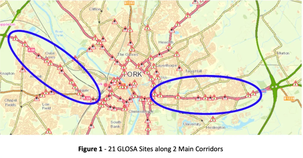
A total of 22 locations were chosen in 2 main corridors leading into and out of the city, along the A59 and the A1079 as seen in Figure 1.
System Design and Development
We had already produced the Advance Signal Time Information (ASTI) service to convert stage changes from our Urban Traffic Management System (Dynniq’s brand name is TMS) into SPaT messages for use by driverless pods; this was demonstrated as part of the on-road public CAPRI Mobility trials at Queen Elizabeth Olympic Park in March 2020. Dynniq’s cloud- based FlowSense and ‘Roadside’ ITS Station (RIS) instances had been developed previously and used for GreenFlow for Trucks, a GLOSA + priority app.
To meet the Council’s requirements, we undertook the following developments:
- A brand-new System Management Tool.
- A new CarFlow York app, based on the GreenFlow for Trucks app.
- The ASTI service was updated to make use of more information from TMS, to communicate with the RIS instances using the standard RIS Facilities Interface (RIS-FI), and to provide SPaT data to York Open Data.
How it Works
Aa junction, the traffic light controller uses its configuration to map traffic light phases to stages and reports stage changes to our TMS, the UG405 Gn reply bits. For phases that are not entirely coincident with stages, the traffic light controller is configured to send phase confirms using additional reply bits.
The TMS reports the stage and phase confirm changes to ASTI. The TMS also provides information about plan and mode changes. If the controller’s plan changes, ASTI requests details about the plan. If the controller’s mode is Fixed Time, ASTI can use the associated plan to predict upcoming stage changes and associated signal group changes. It may also be able to advise speeds on the approaches. The current signal group states, predictions and advised speeds are sent to the RIS instance corresponding to the site using RIS-FI.
The RIS creates and transmits MAP and SPaT messages into FlowSense, where they can be accessed by authorised applications based on geographic location and message type.
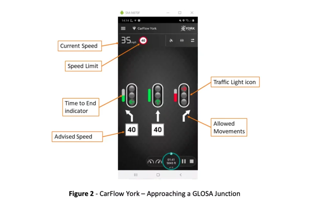
The CarFlow York mobile phone app retrieves MAP and SPaT messages from FlowSense that are relevant to its current location, speed and heading.
The app uses these messages to display information to the driver about the traffic signals being approached, as shown in the following diagram.
York’s Required Changes
Although no additional roadside equipment was needed to implement the GLOSA system, there were some controller and TMS configuration changes required in order to provide phase status data to ASTI for phases that start before and/or end after their associated stages. Having this information allows ASTI to provide more accurate signal states (aspects) to be displayed by CarFlow York.
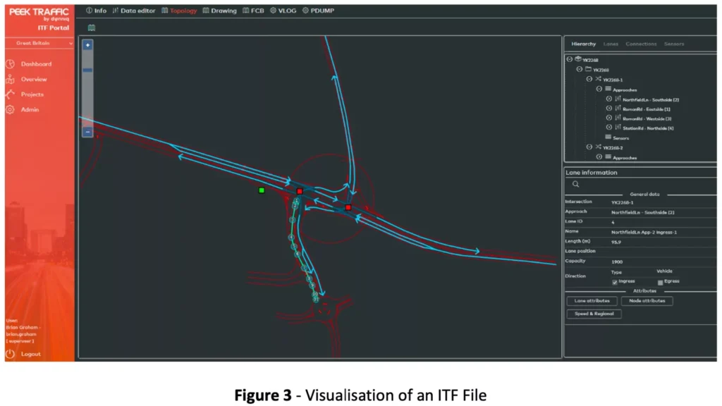
ITF Files
Each GLOSA site requires an Intersection Topology Format (ITF) file to define the locations, attributes and relationships of the lanes, signal groups and intersections at the site. The ITF files have been generated by Dynniq based on CAD drawings produced by the Council. The ITF files are only used within the GLOSA system after certification by appropriately qualified Council personnel.
ITF files are in XML format and contain roughly the same information as a MAP message. We have developed a graphical tool to facilitate the generation and visualisation of the ITF file contents. Once it is certified, an ITF file is exported from the tool and loaded onto the appropriate RIS instance.
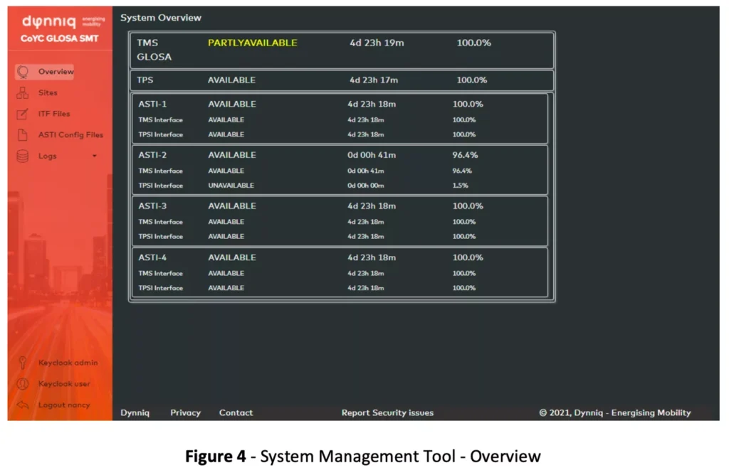
System Management Tool
York required a mechanism to allow monitoring and configuring of the GLOSA system. We developed a web-based System Management Tool (SMT) specifically for the Council. It provides uptime and availability figures for the system as a whole, the individual components, and each GLOSA site.
SPaT, MAP and CAM information for any GLOSA site can be shown by the SMT. In the following figure, MAP information is being used to display the static information about the site: the ingress and egress lanes, conflict areas, intersection and signal group icons. SPaT information is displayed using the colours of the signal group icons, and CAM information is used to show equipped vehicle icons travelling on the map.
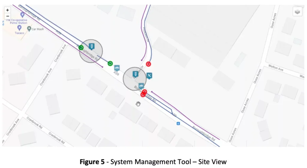
The site view provides OpenStreetMap, Google Maps (as in the previous figure) and Google Hybrid (as in the next figure) map options, and a mechanism to toggle the display of different icon types.
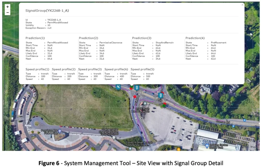
More detailed information can be viewed by selecting one of the icons. The figure below shows additional SPaT information for a specific signal group.
The SMT also allows ITF and other configuration files to be downloaded and uploaded. It can
also be used to view and download diagnostic, performance and utilisation information.
York Open Data
To facilitate data analysis and future innovations, SPaT data is provided by ASTI to the York Open Data platform whenever an intersection or signal group state changes at a GLOSA site. Both XML and JSON formats are provided.
FlowSense SDK
Dynniq’s FlowSense SDK is available for third-party app developers to create new GLOSA apps and augment existing apps (eg Sat Navs). Android and iOS are both supported. Interested parties can be assured of support and collaboration from Dynniq.
Looking Ahead
At the time of writing, the York GLOSA system is being configured at the initial sites. After site and system acceptance, the CarFlow York app (Android and iOS) will be available to the public. At that point, we expect further collaboration with consumer lead application software to develop the system as a whole. The CarFlow York app incorporates a link to a survey site that is controlled by the City of York Council.
(All pictures courtesy of CIty of York Council/Dynniq)