A division of Mercedes-Benz AG-Urban Mobility Solutions (UMS) has been working with Transport for London to develop a road safety ‘dashboard’-a digital tool that has the potential to identify higher risk locations prior to an incident taking place on the network.
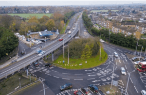
Currently, cities and authorities use information about historic collisions to understand road safety and identify risks on their roads. However, this always requires that there have already been serious incidents there. Daniel Deparis, Head of Urban Mobility Solutions at Mercedes-Benz AG, and Rikesh Shah, Head of Commercial Innovation at Transport for London, partnered to work together on the use of this innovative solution.
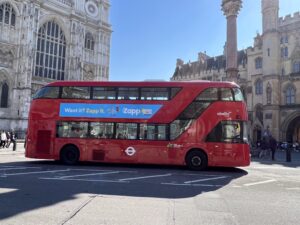
The “Mercedes-Benz Road Safety Dashboard” is based on individual alerts from the driver assistance systems, which are offered in almost all Mercedes-Benz model series now. The systems can intervene in dangerous traffic situations and can reduce the severity of possible collisions or even avoid them altogether. If there is an accumulation of these interventions in a certain traffic area, closer analysis can be performed.

“Jointly with Transport for London and our experts, we started this ground-breaking project for more road safety and have now been able to complete the developmental phase”, says Daniel Deparis, Head of Urban Mobility Solutions at Mercedes-Benz. “Our vision is to protect all road users with our active safety systems. Cooperation with the London specialists contributes to this. Only together we can effectively master the complex challenges in the urban environment and make an important contribution to safety”, said Daniel Deparis.
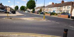
Potential collision spots are automatically identified by individual alerts at the exact GPS location and are immediately analysed using an intelligent algorithm developed by Mercedes-Benz engineers. “It is evident that we can offer city planners a great deal of added value with the data we collect and make available. With our data important decisions about road safety can be made”, says Daniel Deparis. This is possible as the “Mercedes-Benz Road Safety Dashboard” shows potential danger spots for collisions on the road map: easy to use, user-friendly and with lots of information for target-oriented action.
“We are committed to our Vision Zero strategy, which aims to remove all deaths and serious injuries from London’s roads by 2041 and this collaboration with Mercedes-Benz will help us develop new data-led technologies to bring us closer to achieving this” says Rikesh Shah, Head of Commercial Innovation at Transport for London. “With advances in technology, it’s essential that we explore how we can make London’s roads safer. The insights from the tool are fascinating and we are now reviewing how we could further use data from vehicles across London to help us better understand levels of risk – allowing us to plan and introduce appropriate safety interventions. Through collaboration we can create mutual value.”
The anonymised vehicle data from the driver assistance systems are enriched with additional data from London. This includes existing traffic infrastructure such as traffic lights or pedestrian crossings information on collisions that have already occurred, as well as vehicle, cyclist, and pedestrian density. In this way, the “Road Safety Dashboard” shows where action should be taken. The focus is primarily on the most vulnerable road users: pedestrians and cyclists. The focus is primarily on the most vulnerable road users: pedestrians and cyclists. Therefore risky situations in zones around schools, nurseries and universities are prioritized in London.
Mercedes-Benz Urban Mobility Solutions can integrate further features into the “Road Safety Dashboard”, such as measuring traffic volume or warning of slippery roads. Following the successful deployment in London, corresponding projects are underway in several large and medium-sized European cities.
Thanks to sensors such as ultrasound, radar and stereo cameras, objects in the vehicle’s proximity can be detected: in the detection range are vehicles driving ahead, crossing, approaching from behind or even oncoming – but also pedestrians, road markings and various other types of traffic signs.
If an acoustic and visual warning or an autonomous emergency braking is issued, the information is sent to the Mercedes-Benz Cloud and anonymized. Two algorithms process the data in the backend: firstly, the GPS positions with accumulations of occurred interventions are identified. Secondly, these potential collision blackspots are thoroughly analysed, and a risk score is calculated. This information is integrated and portrayed within the Road Safety Dashboard as a digital map.
Data protection has top priority: only if the driver has given his consent to the processing of driver assistance data via the “Mercedes me” app, these warnings or autonomous braking interventions are sent from the vehicle to the Mercedes-Benz cloud and processed there in an anonymised form.
Only then are such warnings or even autonomous braking interventions sent from the vehicle to the Mercedes Intelligent Cloud and processed there anonymously.