Seven million photos have been uploaded to an app that automatically alerts councils to defects.
The technology, using AI, is set to produce the first pothole map of Britain and will make it clearer where repairs are needed and when they are being done, reports the Times.
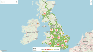
Members of the public have submitted seven million photographs and maps since January, covering a seventh of Britain’s road network. In West Sussex, about 40 per cent of all roads in Worthing have been surveyed and 30 per cent in Horsham. In Eastbourne, East Sussex, 27 per cent of roads are covered. Only 3 per cent of Yorkshire’s roads are charted, said the report.
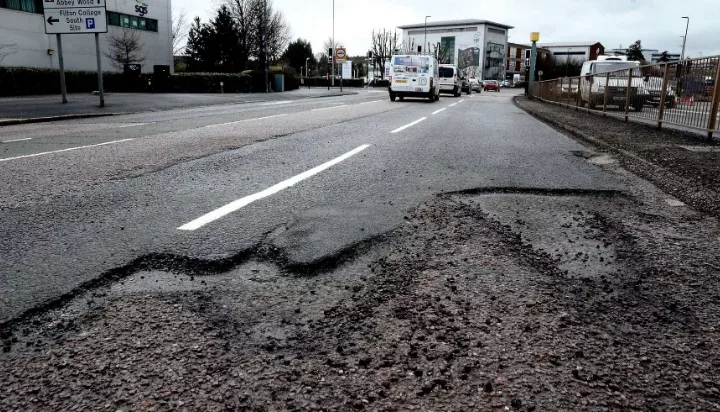
One driver reported 4,753 potholes in 31 days. Both the previous and present governments have said they want to solve the blight of potholes. The Department for Transport is due to announce whether it will certify AI technology to survey the roads.
The cost of road defects to the economy is estimated at £14.4 billion a year, according to the Centre for Economics and Business Research. The author of its report concluded that Britain’s roads were in a worse state than those of Russia and Kazakhstan. KwikFit, the car repair chain, estimates that the annual cost in damage to vehicles is £1.49 billion.
The app identifies, grades and maps out issues with the road surface
Last month the National Audit Office found that although the Department for Transport spent £1.1 billion on local road maintenance in 2022-3, it did not know the full cost because almost two-thirds of the network was not monitored, said the Times report.
Traditional methods of checking the state of the roads are slow and expensive, typically involving inspections by council workers driving slowly and manually noting defects. Drivers can report potholes to the council, but this usually involves filling out an application form on a website.
The app, Stan — short for Safer Travel Around Neighbourhoods — aims to solve this.
Stan identifies potholes and various other defects, measuring their size and depth and then grading them from good to bad. It also notes the precise location of the pothole and logs it on a map. It has about 80 per cent accuracy because cameras find it hard to distinguish between shadows and standing water. The app can generate reports of the roads covered, with a map showing where defects are in order of seriousness, and short written explanations, photographs and video of what it has spotted.
Tom Staniland, managing director of Metricell, the tech company that devised Stan, thought councils and National Highways, which are responsible for fixing roads, would welcome the information when the firm started sending it. He was wrong.
He said: “The first reaction from the authorities to our offer to provide data has been, ‘This is too much risk for us, it will open the floodgates to compensation claims. We couldn’t afford to go out and fix all the potholes that your systems are able to tell us about.’”
Research by the RAC found wildly varying approaches to reports of potholes by councils that replied to a survey. While 54 fixed a pothole of 4cm deep, six waited until they were 5cm deep and 13 stipulated that only those at least 30 cm wide and 4cm deep would be fixed. The RAC is working with Stan and encouraging members to join it, said the Times report.
Last year the government announced £8.3 billion of extra funding for potholes, using funds saved by scrapping the northern leg of HS2. Before the election Labour committed itself to fixing an additional one million potholes in England each year, but has not said whether it will stick to the Tory pledge, despite being urged to do so by the RAC, which wrote to Louise Haigh, the transport secretary, on July 12. Sources say it will consider what to do “in the coming months”.
PIC-RAC