A street-by-street guide that shows how Glasgow’s City Network for active travel will be built has been unveiled.
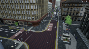
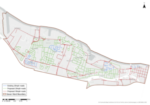
The final delivery plan for the City Network sets out in detail how the council will prioritise its effort to add almost 270km of safer, segregated active routes for walking, wheeling and cycling to 300km of existing routes in Glasgow. Areas of the city have selected after considering factors such as deprivation statistics, pedestrian and cyclist injuries, whether cycling infrastructure is already in place, the amenities available in an area, population size and levels of car ownership.
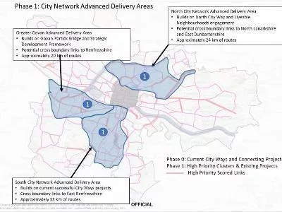
With work on safer routes already advancing in places such as Byres Road, Sighthill, Barrowfield and Parkhead, the next phase of development will focus on areas in the north and south of Glasgow as well as Greater Govan. In a report to the council’s Environment and Liveable Neighbourhoods City Policy Committee, a total of 77km of cycle ways and footpaths are expected to be built in these three areas that add to existing or emerging routes and create possible connections with neighbouring local authorities.

A total of five phases of design and construction work are anticipated between now and the early 2030s that will eventually ensure the City Network is easily accessible in all parts of the city. The final delivery plan for the City Network identifies all of the streets currently identified for inclusion in the network’s route map. While precise routes may be subject to some change during detailed technical design work, the Delivery Plan indicates how the entire city will be served by safe, dedicated cycle infrastructure.
Councillor Angus Millar, City Convener for Transport, sees the City Network as vital element of Glasgow’s effort to tackle the transport-related carbon emissions that fuel climate change. By providing safer places for active travel, he is convinced that more and more residents will have greater confidence to make walking, wheeling and cycling their preferred choice for everyday journeys.
Councillor Angus Millar said: “The final delivery plan provides a clear path to creating a City Network for active travel in Glasgow. The City Network will transform walking, wheeling and cycling in all parts of the city and we now have a detailed, street-by-street guide to how our ambitions will be achieved.
“The aim of the plan is to create connections with existing infrastructure that ensures that more and more parts of the city are accessible by safe, segregated infrastructure that prioritises active travel.
“But how we roll-out the network must also be socially just and so deprivation, levels of levels of car ownerships and the extent of active travel injuries in certain areas have also been key considerations in where we will focus our efforts.
“There is still a great deal of work to be undertaken and we will be engaging with local communities on detailed designs. What we now have is a clear way forward for our City Network and that will allow us to transform the active travel experience in Glasgow.
“By supporting a roll-out of new infrastructure for routine trips by walking, wheeling and cycling , we can transform how we get about Glasgow. The City Network is crucial to creating a sustainable transport system that tackles carbon emissions and moves us closer to becoming a net zero city.”
Plans for the North City network in the first phase of the delivery plan aim to develop 24 km of routes across areas such as Ruchill, Possil, Springburn, Royston and Blackhills. These routes will also connect with Sighthill and the new active travel bridge across the M8.
A further 33km of routes are planned for the South City network, which will add to successful work on the South and South West City Ways and extend into areas such as Pollokshields, Shawlands, Battlefield, Cathcart and Newlands. It is hoped the development of these can lead to connections with East Renfrewshire.
The first phase of the delivery plan also identifies almost 20km of potential routes in Greater Govan, which will take in long stretches of Govan Road, Paisley Road West and Shieldhall Road as well as parts of Cardonald and Craigton.
Full details of all the phases of proposed work the City Network Final Delivery Plan can found in the papers presented to the Environment and Liveable Neighbourhoods City Policy Committee. The paper has been referred to the council’s City Administration Committee for final approval.
The committee also heard a separate report on plans to support people to make more sustainable travel choices. The Travel Behaviour Change Strategy aims to to ensure the council gets the best return on investment in sustainable transport infrastructure by generating the conditions that encourage people to see walking, wheeling and cycling as the first choice for everyday, local journeys.