Lincolnshire Resilience Forum (LRF) has gone live with new geospatial and drone technology from Esri UK to help it better prepare for emergencies across the county, including flooding, loss of critical infrastructure, pandemics or severe weather. Image recognition and drone software are among new applications helping to create real-time intelligence and an improved understanding of potential catastrophes.
Covering over 2,000 square miles and a population of more than 750,000, the LRF’s objective is to save and protect human life, relieve suffering and contain emergencies, limiting their escalation by ensuring comprehensive readiness. One of 38 Local Resilience Forums in England, the multi-agency partnership consists of over 30 category 1 and 2 responders, including local authorities, government agencies, police, emergency services, NHS and health bodies, utilities and transport providers.
New systems are being used to identify unknown caravans using drone and satellite imagery, to gain a more accurate understanding of where residents need to be evacuated fromin the event of a major flood. Preparing for tidal inundation is a top priority for the LRF due to Lincolnshire having one of the largest single landmasses in the country at risk of such an event, along with Europe’s highest density of static caravans at more than 34,000.

Esri drone software is making aerial data capture faster and more accurate to create 3D digital twins of potential higher risk zones, supporting better understanding of access and evacuation points in relation to homes and other properties. The new deployment means the LRF can create digital twins more quickly, particularly for Control of Major Accident Hazards (COMAH) locations, which involve dangerous substances such as gas and oil refineries.
“Responding to large emergencies – particularly flooding but also major transport incidents or the loss of critical infrastructure – is a crucial role of public services. With the climate crisis comes more extreme weather events, which means community resilience is even more important,” explained Steve Eason-Harris, Emergency Planning Officer at Lincolnshire County Council, who is the lead officer for GIS and Resilient Communities for the LRF.
“Lincolnshire is a large county with no motorways and few dual carriageways so response and evacuation planning is critical. These new innovations are enabling emergency planners to model risks affecting the county to maximise response, improve communication and coordination and reduce, as practicably as possible, the impacts on the wider communities of the county. Creating the new caravan dataset in particular will dramatically improve intelligence.”
Identifying static caravans is traditionally difficult due to licensing regulations, land ownership and registry data. Now with new deep learning tools available, the LRF is exploring and developing ways of employing drone and satellite imagery and GIS to identify previously unknown caravans. Tourism is the lifeblood of many coastal regions in the country but this can increase risks to coastal populations residing in caravans when holiday seasons lengthen into storm periods. In Lincolnshire, this traditionally runs from October to March.
“We’re aiming to solve a huge challenge and having the latest geospatial technology means the LRF can respond more effectively. Constant innovation is critical at the LRF, the objective being to use new systems to ensure we get the right resources to the right people at the right time,” continued Eason-Harris.
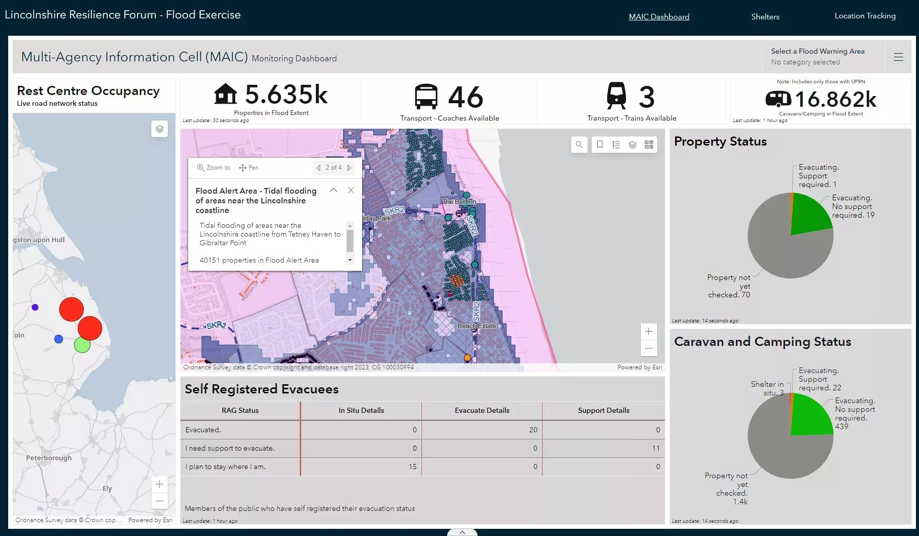
At the core of the solution lies an Esri real-time mapping dashboard, providing a common operating picture, which went live in summer 2022 and was used extensively during Storm Babet in October 2023. Available online, on mobile devices and giant touch screens in the County Emergency Centre, it integrates data from over 30 agencies to allow rapid decision making. The system provides a faster and more advanced method of showing partners what the situation is before, during and after an emergency, compared to paper maps and spreadsheets.
Other new GIS projects at LRF include developing a workforce application for deploying, tracking and communicating with volunteers in the field to support vulnerable people who need assistance the most. The system will update the control centre via a mobile app when volunteer tasks have been completed and alert the team with any requests for medical intervention or transport assistance. Data from the app will also feed directly into the mapping dashboard in the control centre.
(Picture – Lincolnshire Resilience Forum)