Motorists with smartphones could help highway chiefs maintain road quality by sending ‘crowdsourced’ data from their mobiles that would allow engineers to assess when carriageway repairs are needed, according to a new study. by researchers at the University of Birmingham.
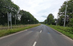
Road roughness is an important measure of condition and ride quality, but many road athorities around the world with large road networks often lack the resources to regularly check the state of their highways and make informed maintenance decisions, according to the university.
Using high resolution three-axis accelerometers and GPS tracking already built into smartphones – together with a low-cost app – to record how a vehicle moves vertically in relation to the carriageway can provide a useful measure of road roughness for civil engineers.
Researchers at the University of Birmingham have studied the feasibility of using smartphones in this way, publishing their findings in Journal of Infrastructure Systems.
On most road networks, road roughness is usually used as the measure of functional condition because it can be related readily to road use costs and measurement can be automated.
Co-author Dr. Michael Burrow, Senior Lecturer at the University of Birmingham, commented: “The most accurate automated methods of assessing road roughness use vehicles fitted with lasers, but even assessing the roughness of a reasonably sized network can be costly. An attractive solution is to use acceleration sensors built into most smartphones – because smartphone ownership and use are widespread, we can foresee an approach where the condition of road networks is assessed using crowdsourced data from these mobile devices.”
Maintaining roads at an appropriate standard encourages economic development and minimises road use costs such as travel time, fuel efficiency, vehicle repairs and accidents. It also provides social benefit and reduces the environmental impact of transport.
In order to make best use of scarce resources, road agencies worldwide prioritise maintenance according to the socio-economic returns – achieving this by regularly assessing road surface and structural condition.
The International Roughness Index (IRI) is the most commonly used measure of road roughness, but even assessing the roughness of a reasonably-sized road network can be costly using ‘traditional’ technology.
For example, the cost of collecting road roughness data in the United States is between $1.4 and $6.2 per kilometre, depending on the state – in Illinois, which has 224,719 km of roads, the annual cost of data collection is $1.4 million.
Decision-making using roughness data collected using a smartphone system could allow road agencies to:
- Produce a regular low-cost summary of the entire road network’s condition;
- Use network-level models to evaluate and compare maintenance policies, as well as assessing road use and road agency costs; and
- Screen roads to identify and prioritise road sections requiring maintenance.
“Routine inspection of the condition of a road network could be achieved using low-cost data collection systems on smartphones with similar characteristics inside a fleet of vehicles of similar types, travelling at normal traffic speeds,” noted Dr. Burrow.
“Vertical acceleration data from smartphones could be analysed using machine learning algorithms to enable IRI to be predicted to a similar accuracy as would be expected from a visual inspection, but with improved repeatability and reproducibility.
“A particularly useful application could be the assessment of the condition of low-volume rural road networks in developing countries where the majority of rural roads are constructed from either gravel or earth and where smartphone ownership is surprisingly high.”