Transport bosses in the West Midlands are harnessing the power of 5G technology to cut traffic congestion on some of the region’s busiest roads.
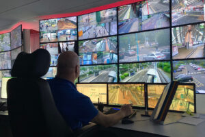
A network of 5G sensors will relay live traffic information to the regional control centre to enable swift action to be taken as queues build up – perhaps diverting buses, implementing diversions and issuing instant warnings to motorists.
The traffic data will also be used to spot traffic trends and help plan future transport development.

West Midlands 5G (WM5G) and Transport for West Midlands (TfWM) have joined forces to work on the project to demonstrate how 5G technology can make a major impact on our road network.
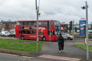
The project centres around the Key Route Network, a set of A and B roads equivalent to 7% of the available network but which carry over half of all traffic within the region.
This has resulted in congestion hot-spots affecting drivers and bus passengers alike something which the Road Sensor Networks project hopes to alleviate.
In its first phase, the project aims to capture a more granular picture of traffic flow through the deployment of various of 5G enabled sensors, radar and cameras across the key route network. This insight will prove critical in reducing congestion and predicting and managing increasing levels of traffic particularly during major events or incidents.
TfWM, which is part of the West Midlands Combined Authority (WMCA) has been working with partners such as WSP, Siemens, Earthsense and Vodafone in delivering the project.
Mayor of the West Midlands Andy Street, who chairs the WMCA, said: “This sensor network is yet another example of how the West Midlands is at the forefront of 5G technology and the cutting edge of transport innovation. 5G is far more than just quicker streaming of movies, and this works shows the difference it will make to people’s everyday lives across the region.
“The Road Sensor Network project will form a key part of planning and developing our future transport network, allowing us access to data that would otherwise have not been possible without 5G. Projects like this show how critical it was we got ahead of the game and won the right to be the UK’s first regional 5G testbed back in 2018.”
“The Road Sensor Network project will help make our roads safer and more efficient, this will give the West Midlands a critical advantage when considered for future development and investments.”
The project supports the Regional Transport Coordination Centre (RTCC) and Local Authority Traffic Control Centres to provide real-time anonymised insights about traffic flow and capacity on the roads.
The project will also allow us to develop better traffic models or “digital twins” allowing better understanding of changes in travel behaviour as the region comes out of lockdown. These models also allow us to prioritise road improvements and support new developments, key to “building back better”.
To date the region has relied on manual surveys of traffic flows using pneumatic tubes or limited coverage of CCTV and Automatic Number Plate Recognition (ANPR) cameras to gauge the number of vehicles and journeys being undertaken on the region’s roads. This approach is limited in terms of the data and information it provides, making it difficult to accurately predict or model transport activity on the road network.
5G’s high speed and low latency (the time from action to reaction) enables the data captured to be anonymised and transferred to the RTCC in near-real time, building a more accurate simulation model of anticipated traffic and improving congestion management. It also supports the collection of a much richer set of data including pedestrian, cycle movements and supports evaluation of Future Transport Zone initiatives such as demand responsive transport and E-Scooters.
The Road Sensor Network will also deploy environmental sensors to gain greater insight into noise levels, particulates, CO and CO2 counts, as well as weather and humidity data. This kind of information will support the TfWM in meeting air quality objectives and help the region reduce its emissions footprint; which in turn will improve the health and wellbeing of local citizens and road users.
Cllr Ian Ward, WMCA portfolio holder for transport and leader of Birmingham City Council said “Making the regions roads greener, better connected and less congested will bring about a great number of benefits to residents and local businesses. Digital solutions such as the Road Sensor Network will be critical in delivering the insights necessary to action such tangible long-term change.”
Chris Holmes, transport programme director for WM5G said: “The Road Sensor Network project is a great example of how deliberate application of connected technologies can provide the insights necessary to solve some of our biggest transport problems.
“The anonymised, GDPR compliant information captured during the project will be sufficient to start improving the flow of traffic across the West Midlands’ Key Route Network and improve access to the region. Better connected roads will ultimately support local financial growth as it will be quicker and easier to travel for business, leisure, or academia.”
The next stage of the £5.8 million Road Sensor Network Project will see around 280 sensors provided by Vivacity and Vaisala deployed across the seven constituent authorities of the West Midlands Combined Authority area, before its conclusion in March 2022. It is hoped the findings will support other regions in developing similar networks to ease congestion hotspots and more intuitively manage traffic flow.
(Picture – Yay Images)